Irwin River
Location
Dynasty has secured five exploration licences covering 762km2 in the northern Perth basin, east of Dongara and Geraldton.
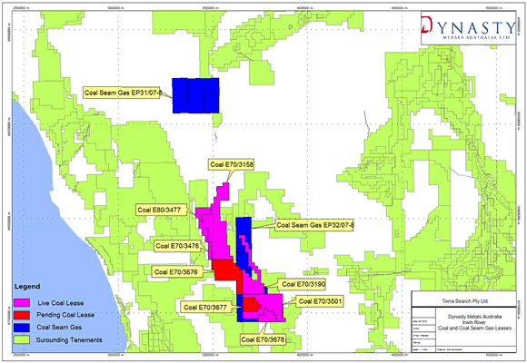
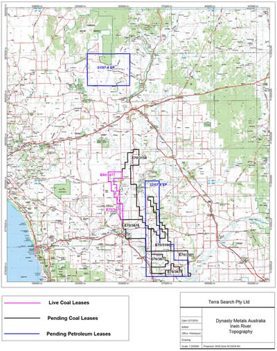
In addition to EPL’s, Dynasty has also applied for Petroleum Exploration Licenses and Mineral Exploration Licenses over part of these areas, see Figure 1.
Figure 1 – DMA Tenements Irwin River
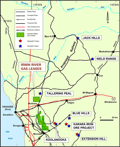
Figure 2 - Infrastructure
Dynasty is exploring these areas for coal and coal seam methane. The tenements are well located for development with respect to major iron ore resource development projects, existing gas reticulation infrastructure, existing and proposed ports and regional infrastructure, see Figure 2. Oil and gas exploration in this region of the Perth Basin has been undertaken over the past 40 years and has resulted in a number crude oil and gas discoveries in various geological units ranging from Late Permian to Late Jurassic in age, see Figure 3.
Figure 3 – Irwin River Leases and Underlying Geology
Exploration has resulted in the development of a number of natural gas production wells which supply natural gas to Perth domestic and industrial customers. Coal exploration in the region has also been ongoing over the past 100 years and has delineated a number of coal seams which historically were not deemed commercially viable.
Exploration targeting coal seam methane has not been undertaken in the area although oil and gas explorers have reported gas flows when drilling the Irwin River Coal Measures, see Table 1.
Table 1 – Source Rocks Oil and Gas
| NAME | TYPE |
| Permian Irwin River Coal Measures | Potential gas condensate source |
| Lower Triassic Kockatea Shale | Primary oil source |
| Lower Jurassic Cockleshell Gully Fm | Gas and condensate source |
| Mid Jurassic Cadda Shale | Gas, condensate source at Warro #1 |
| Mid to Upper Jurassic Yarragadee Fm | Gas source at Warro #1 |
The Dongara Gas Field produces principally from the basal Triassic Sandstone, and also from the Permian Irwin River Coal Measures and the Permian Carynginia Formation. Some oil occurs in the Basal Triassic Sandstone. The same formation also produces gas at the Yardarino and Mondarra Fields (non-commercial oil is present at Yardarino). The Gingin and Walyering Fields have historically produced commercial gas flows with minor condensate from the Cattamarra Coal Measures of the Lower Jurassic Cockleshell Gully Formation which overlies the Irwin River Coal Measures, see Table 2.
Table 2 – Reservoir Source Rocks
| NAME | TYPE |
| Lower Permian Highcliff sandstone | contains gas and oil at Arrowsmith #1 |
| Irwin River Coal Measures | contains gas and oil at Arrowsmith #1 |
| Lower Permian Carynginia Formation | oil at Arrowsmith and Yardarino |
| Lower Permian Carynginia Limestone | gas at Woodada |
| Lower Permian Wagina Sandstone | contains oil at Mondarra. |
| Wagina Sandstone Basal Trassic Dongara Sandstone | produces gas and oil at Dongara-Yardarino |
| Kockatea Shale | sand lenses contain oil at many sites, including Mt Horner, Arrowsmith, Mt Adams and North Erregulla |
| Upper Triassic Lesuer Formation | excellent reservoir but overlying seal is lacking, no accumulation yet found |
| Lower Jurassic Cockleshell Gully Fm | produced gas at Gingin, and Walyering. |
| Middle Jurassic Cadda Formation | gas influx into Warro #1 from thin sands caused suspension of the well and side-tracking. |
| Middle-Upper Jurassic Yarragadee Fm | contains non commercial gas at Warro #1 |
Coal Potential and Targets
Figure 4 – Stratigraphy showing Irwin River and Cattamarra Coal Measures

Field studies and drilling from previous exploration in the area’ indicate that the coal resources of the Irwin River Coal Field lie in a moderately complex geological setting and consist of a low rank black coal. The coalfield, which covers and area of approximately 170 square kilometres, outcrops intermittently over a strike length of about 44 km. CRA in 1986 estimated a substantial Inferred Resource based on widely spaced drilling data (circa 4km centers) and comprising narrow seams many of which were deemed non-recoverable at the time. (GSWA Report 44 pg 29, Le Blanc and Mory 1996).
There are nine principal seams in the coalfield, each of which locally exceed 0.5 metres in thickness. These are (from the top): seams A, B, C, C lower, D, E, F, G and H. The stratigraphic relationships are shown in Figures 4 and 5.
Figure 5 – Coal Seams of the Irwin River Coal Measures*
*REPORT 44 OF GEOLOGICAL SURVEY OF WESTERN AUSTRALIA - GEOLOGY AND PERMIAN COAL RESOURCES OF THE IRWIN TERRACE, PERTH BASIN WESTERN AUSTRALIA - by G. Le Blanc Smith and A.J. Mory
Seams exceeding 1.5 m in thickness include C Seam, F Seam, and G Seam.
Dynasty Exploration
Over the past year Dynasty has recorded approximately 100km of 2D seismic over its Irwin River area. The results from this work interpreted by Dynasty’s geophysical consultants, have delineated two areas which the company believes warrant further exploration. The southern area seismic results show coal seams at >400m in depth which represents depths where coal seam methane can be generated and stored within the seams, see Figure 6.
Figure 6 – Southern Seismic Section

The second area made up of six blocks, is part of the northern portion of the tenement area. The 2007 seismic survey shows a significant section which appears to be coal seams at a relatively shallow depth. This puts the coals within that window where coal seam methane (if present in the coals) can be easily tested by a shallow drilling program, see Figure 7.
Figure 7 – Northern Seismic Section

Future exploration
Historical evidence and Dynasty seismic work suggest the coal measures on its Irwin River Tenements, represent a valid exploration target for coal seam methane and that the inter-bedded sands within the coal seams may also contain methane migrated from the coal seams. The Permian Coal Measures are overlain by Triassic shales which may act as a seal preventing escape of gases. Further interpretation and exploration is planned for future reporting periods.


